
1. The Crisis of Industrial Grazing and the Call for Technical Sovereignty
Traditional industrial grazing is a legacy of the extractive era, relying on fixed-paddock systems that ignore the pulse of the living landscape. These rigid infrastructures lead to a predictable tragedy: overgrazing in high-traffic zones and stale, under-utilized forage elsewhere. The result is a degradation of the soil’s metabolic capacity, leading to erosion and nutrient-void pastures. To heal the land, we must pivot toward algorithmic precision—a reclamation of the biological commons where grazing mimics the nomadic, high-density pulses of wild herds.
Achieving this does not require a surrender to proprietary “black box” technologies. True land stewardship requires technical sovereignty: the ability of the land steward to own their data, their tools, and their decision-making logic.
Proprietary Subscriptions vs. Open-Source Sovereignty
- Financial Freedom: Tools like QGIS and Python liberate the farm from the “software-as-a-service” debt cycle, eliminating recurring licensing fees that drain farm equity.
- Operational Autonomy: Stewards are no longer captive to a single vendor’s development roadmap or hidden data silos.
- Biological Customization: Open-source algorithms permit the adjustment of logic to specific micro-climates and ecologies rather than forced adherence to a one-size-fits-all model.
- Deep Interoperability: By utilizing OGC/ISO open standards, we ensure that data from disparate sensors, satellites, and IoT devices flow seamlessly without “walled garden” barriers.
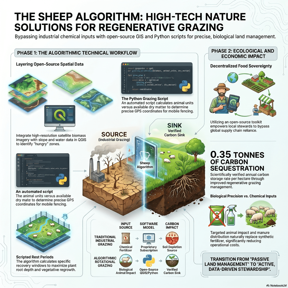
The “Sheep Algorithm” is the implementation of this vision. It is a biological precision method that utilizes geospatial intelligence to synchronize herd movement with the regenerative thresholds of the pasture.
2. Mapping the Invisible Forage: The QGIS Environment
The first step in algorithmic grazing is the construction of a “digital twin” of the pasture within the QGIS environment. This spatial framework allows us to visualize biomass quality and quantity across vast acreages. Using OGC/ISO protocols, we integrate diverse geospatial data streams:
- WMS/WMTS (Web Map Service/Tile Service): Used for streaming high-resolution base maps and pre-generated tile sets.
- WCS (Web Coverage Service): Essential for accessing raw, multi-band raster data required for biomass modeling.
- WFS (Web Feature Service): For managing vector data such as existing fence lines, water infrastructure, and exclusion zones.
We ingest Cloud-Optimized GeoTIFFs (COGs) from Sentinel-2 and Planet imagery to build our foundation. To ensure the highest fidelity, we utilize sub-meter precision via triangulation with local ground stations. By analyzing the Visible (B2, B3, B4), Red-Edge (B5, B6, B7), and Near-Infrared (B8, B8A) spectral bands, we can map canopy structure and biochemistry. By layering this data over Slope (digital elevation models) and Water Access distances, we identify “hungry” zones for targeted grazing and “recovery” zones that require exclusion.
3. Calculating Biomass via Sentinel-2 and Random Forest Regression (RFR)
Predicting forage quality without labor-intensive destructive sampling is achieved through Random Forest Regression (RFR). This machine-learning approach correlates ground-truth NIR (Near-Infrared) harvester data with satellite spectral signatures.
Technical performance is driven by the specific influence of the Red-Edge bands (B5, B6, B7) and Narrow NIR (B8A), which have proven to be the most influential predictors in achieving model R^2 values between 0.77 and 0.86. These bands are sensitive to chlorophyll concentrations and cellular structures that indicate real-time nutritional status.
The RFR workflow identifies four critical forage quality attributes:
| Forage Attribute | Definition | Impact on Performance/Environment |
| Crude Protein (CP) | Total nitrogen content. | Optimizes rumen microbial synthesis; prevents nitrate leaching when managed at peak. |
| Water-Soluble Carbohydrates (WSC) | Soluble plant sugars. | Enhances digestibility; reduces the acetate:propionate ratio in the rumen, favoring a less methanogenic pathway. |
| Neutral Detergent Fiber (NDF) | Structural plant fraction. | Regulates voluntary dry matter intake; necessary for maintaining proper rumen motility. |
| Acid Detergent Fiber (ADF) | Cellulose and Lignin. | Direct predictor of digestibility; high ADF reduces energy availability and increases methane intensity. |
4. The Python Grazing Script: Logic and Automation
With a high-resolution quality map, a Python script automates the logic of movement. The core calculation balances Animal Units (AU)—representing the total metabolic demand of the herd—against Available Dry Matter (DM) calculated from the RFR biomass model.
To maintain precision in continuous behavior segments (CBS), the script utilizes a 3-second sliding window to classify behavior. This short window is critical; while larger windows (11s) may appear accurate in static tests, they fail to capture the rapid transitions in grazing sheep, leading to misclassification. The script categorizes movements into Walking, Standing, Grazing, Lying, and Running.
A primary driver for movement timing is Sward Surface Height (SSH):
- Short SSH (2–3 cm): Triggers a “Move Required” status, as sheep on short swards increase walking behavior and decrease forage intake efficiency.
- Medium SSH (5–6 cm): Indicates optimal grazing efficiency where grazing time is maximized.
- Tall SSH (8–10 cm): Correlates with increased resting and rumination time, allowing sheep to meet nutritional needs with fewer bites.
Sample Output Logic: Current_Paddock_ID: 204 Available_DM: 1250 kg/ha Animal_Units_Required: 45 AU Target_Paddock_ID: 102 Fencing_Points: [45.1234, -123.4567; 45.1235, -123.4568] Water_Trough_Loc: [45.1230, -123.4560] Estimated_Grazing_Duration: 36 Hours
5. Quantifying the Carbon and Economic Impact
Algorithmic rotation transforms the farm into an active carbon sink. By timing grazing to the plant’s metabolic peak and preventing over-defoliation, we maximize photosynthesis and root exudation, pumping carbon into the soil profile.
Impact Metrics include:
- Soil Organic Matter (SOM): Measurable spikes as root systems are stimulated and manure is distributed with precision.
- Fertilizer Reduction: Decreased reliance on synthetic inputs by utilizing targeted animal impact to cycle nutrients.
- Carbon Sequestration: Transformation of the farm from a carbon source to a sink through biological density.
Real-time soil monitoring is integrated via the SensorThings API, utilizing the “Observations and Measurements” data model. This provides a standardized, interoperable stream of soil moisture and nutrient data that informs the grazing script’s feedback loop.
6. Implementation Roadmap: The Steward’s Toolkit
To deploy the Sheep Algorithm, land stewards must master a specific open-source stack:
- QGIS: The central dashboard for visualizing the pasture’s digital twin and analyzing OGC service layers.
- Python: For running the machine learning RFR models and the grazing automation scripts.
- Sentinel-2 & Planet Data: The primary spectral source for biomass and quality monitoring.
- SpatioTemporal Asset Catalogs (STAC): The hierarchical standard for browsing and filtering localized datasets, allowing for the efficient handling of Cloud-Optimized GeoTIFFs (COGs).
The transition from passive land management to a data-driven, regenerative workflow is the essential leap for the modern steward. By adopting the Sheep Algorithm, we do not just manage a farm; we architect a decentralized, sovereign, and self-healing food system.